
HIKING - MONROVIA PEAK AND OTHER HIKES IN THE SAN GABRIEL MOUNTAINS
- Dec 16, 2017
- 6 min read
"Mountains have a way of dealing with overconfidence."
~Hermann Buhl
Making a list and doing a number of hikes in the San Gabriel Mountains was on my Updated Bucket List for Year 77. Monrovia Peak is not the highest peak in these mountains, but I've lived in Monrovia for 47 years and Monrovia Peak is right in my backyard. I have thought for many years that I should hike to it's summit and Art W and I almost made it in the spring of 2011, but about a mile from the top we ran into a thick fog bank and we decided not to continue.
Click Photo to Enlarge - Use Arrows for Next Photo


So my YEAR 77 seemed like the appropriate time to complete this item. We selected Thursday December 7th for the hike and Art, Gerard, Harry and I were prepared to attack the hill. Then Southern California caught on fire! Beginning on the weekend prior to our planned hike date the winds began, the humidity dropped, and several fires started nearby (I don't yet know the actual cause of the fires). By Tuesday, Canyon Park (our access to the trail-head) closed until further notice, and the closure went beyond our hike date. But we were able to arrange for everyone to hike the following Friday, December 15th. There was a "Red Flag Warning" (high Santa Ana winds) posted for that day also, but fortunately Canyon Park did not close the gate.
It was cool at 8:00 AM as we assembled at Barbara and Harry's house to catch the "Barbara Transport" into Canyon Park. The forecast was sunny, with the high expected to be 82 degrees. Barbara had kindly agreed to drive us into the Park and up the asphalt road past the Sawpit Dam and the Trask Boy Scout Camp, to the closed gate on the fire road where we planned to begin our hike. The photo below is at the gate -- our Trailhead -- Art W, Gerard, Ron, and Harry.

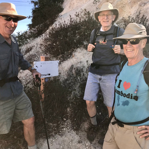
Beginning at the gate (which is near the Ben Overturff Trailhead), we hiked up the fire road to White Saddle (the little white sign between us says White Saddle). We used the Strava app on our cell phones to check the mileage and it was 3.5 miles from our trailhead to White Saddle.
Click Photo to Enlarge - Use Arrows for Next Photo


The road splits at White Saddle and we went left (north) and continued up the fire road another 3 miles to the Rincon Road/Red Box split (cumulative 6.5 miles at this point).
Click Photo to Enlarge - Use Arrows for Next Photo


We turned left at the Rincon Junction and went about 1 mile, passing some power lines, to a ravine on the left. At this point we scrambled up the ravine through some brush to a firebreak (we had read that there was a "use trail" in this area, but we never found it). In a relatively short distance we reached a "firebreak" and turned right toward the top. The firebreak had been created with a bulldozer, so the ground was very rough, loose dirt and rock. And it was steep! The photo below shows one section of the firebreak. We literally had to crawl some parts of this last 7/10 of a mile to the summit. I wouldn't wish this part of the hike on my worst enemy.

We finally reached the top a little before 12:30 pm and the cumulative distance at this point was 8.2 miles. The first photo below shows the actual summit as a hump behind the guys. The next photo shows the marker on the summit, identifying the location. Next to the marker was a red can enclosing notebook logs signed by previous hikers. The last signer before us was in the last week of November of this year. We all signed and dated the log. Gerard wrote, "I won't do this hike again", Art put, "A ball buster!", I wrote, "There must be an easier way to the top." The final photo was taken over Art W's shoulder as we were eating lunch. The mountain in the distance is Mt. Wilson. With the naked eye you can clearly see the towers on top. The view in all directions was wonderful, although a little hazy in the distance.
Click Photo to Enlarge - Use Arrows for Next Photo


We rested for 15 minutes or so and each ate what we had brought (I had a great turkey sandwich). Then we headed back down the same way we had come. Going down the firebreak was not as much work as going up, but it was difficult, and tricky due to the loose rock.
Click Photo to Enlarge - Use Arrows for Next Photo


At the end of the firebreak we followed the fire road on down the mountain, arriving at our trailhead a little after 3:30 pm. Harry had called Barbara a little earlier and she arrived in the car to pick us up only minutes after we got there. Barbara and Harry left us at the Terrill home and Art, Gerard and I drove to the Mt. Lowe Brewery to have a brew as a reward for the accomplishment. I was tired (my legs were barking) but we were all glad we had done this hike and felt like it was an enjoyable day.
Summary: The summit of Monrovia Peak is just 5409 feet, but it's a long hike - 16.4 miles round trip from trailhead we chose. That's a long way to walk, with a strenuous section at the top, and even on the way down our legs were tired and the bottoms of our feet were burning. But the views of the vegetation along the road and of the surrounding valleys were terrific and the conversation along the way was fun. We were on the trail about 7 1/2 hours.
A Little History - Hikes in the San Gabriels: I've lived in or near the foothills of the San Gabriel Mountains the entire time I've been in California. It wasn't until the early 2000s, when I was running less and was no longer employed or doing consulting, that I began doing much hiking. I bought a hiking book, Trails of the Angeles - 100 Hikes in the San Gabriels, and began reading about hiking the local mountains. I highlighted a list of hikes that appealed to me and began doing them one at a time. Alphabetically the list was Bridge to Nowhere, Chantry Flat to Strurtevant Falls, Deer Park, Eaton Canyon, Echo Mountain, Fish Canyon Falls, Henninger Flats, Icehouse Saddle, Inspiration Point, Monrovia Canyon Park (including the Falls and White Saddle), Monrovia Peak, Mount Lowe Railway, Mount San Antonio (Old Mt. Baldy), Mount Wilson, Mount Wilson Toll Road, Orchard Camp, Overturff Trail, Sawpit Canyon, Switzer Falls, and Throop Peak. I have done all the hikes I put on the original list except the Bridge to Nowhere, Inspiration Point, Monrovia Peak, Mount Wilson on the trail that continues from Orchard Camp, Switzer Falls and Throop Peak.
About the same time that I began hiking in the local mountains, I read about a hiking group in Big Bear that were planning to hike what they had designated "The Seven Summits of Big Bear." These hikes were in the San Bernardino Mountains and I will write about those hikes in a separate blog covering those mountains.
The photos below are of hikes I have done in the San Gabriel Mountains. Photos from the left:
1st row: Me, Gerard and Art W in August 2012 at the summit of Mt. San Antonio (Old Mt. Baldy) the 5th highest peak in So. California at 10,069 feet elevation; my first attempt at Monrovia Peak in April 2011 (Art and I stopped about one mile short because of fog); At White Saddle with Aki when I hiked it with Donna in February 2011. 2nd row: Eaton Canyon Falls when I hiked it with Donna in December 2012; Tracy at the Twin Falls entrance to Deer Park in March 2012; Kate, me, Tracy and Jen at the summit of Ice House Canyon in June 2014; 3rd row: Me, Tracy, Art W., Lilah and Jen at Fish Canyon in May 2015; Jen, Tracy and me at Echo Mountain in December 2015; Tracy, me and Jen at Henninger Flats in March 2016; 4th row: Tracy, me and Jen at Orchard Camp in February 2016; Me and Espi on the Descanso Trail in June 2016 (not in the San Gabriels but a fun hike in the La Canada/Flintridge Hills); and Harry and I at the Canyon Park Falls in November 2016. Each of these hikes has it's own personality and can be enjoyed multiple times. Of the hikes in the San Gabriels, I plan to hike Deer Park, Monrovia Peak, The Road to Nowhere, The Bridge to Nowhere, Henninger Flats, Echo Mountain and Orchard Camp during my YEAR 77.
Click Photo to Enlarge - Use Arrows for Next Photo


Comments