
2019 - BIG BEAR TRAIL HOST VOLUNTEER - UPDATED
- Jun 2, 2019
- 15 min read
NOTE: This is a "Serial Blog" that will be updated periodically and republished. The Introduction and Pacific Crest Trail sections immediately below will stay the same, but periodic activities will be summarized below these sections, with the most current activity first.
_______________________________________________________________________
Introduction
The U.S. Forest Service and the Southern California Mountains Foundation have formed a partnership for a Trail Host Program in Big Bear Valley's San Bernardino National Forest. Volunteers in the Trail Host Program are charged with welcoming, educating, and supporting Non-Motorized Trail users, working to monitor the forest and it's trails, and reporting required repairs. This program appeals to me because I can do some good, enjoy hiking while doing it, and not break my back doing shovel work. You can read more about the Foundation by clicking here.

Bennett Rossell is the Non-Motorized Trails Coordinator and manages the volunteers in the Trail Host Program from his office in the Big Bear Discovery Center. The Discovery Center is a wonderful resource for outdoor enthusiasts interested in the Big Bear area and can be reviewed by clicking here. I have hiked many of the trails in Big Bear (I hiked the Seven Summits of Big Bear with a local hiking group in 2009) and I have become interested recently in hiking the portion of the Pacific Crest Trail that winds through Big Bear Valley. We have a cabin in Big Bear and I love spending time there, so joining the Trail Host Volunteers seemed like a natural. I met with Bennett April 12, 2019 and signed up for the program.
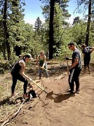
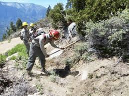
Trail Host Volunteers are asked to spend a minimum of 90 hours per year out on the trails in Big Bear Valley, monitoring them and reporting trail sections in need of maintenance. I'm hoping that friends and family members will periodically join me in hiking the trails throughout the Valley. In a separate program, Trail Steward Volunteers actively manage trails in the forest by providing quick, immediate trail repair to keep trails open and safe. These volunteers receive training and orientation on how to perform coordinated, autonomous trail work safely and effectively.
I plan to update this blog periodically with trail monitoring activities. I don't want to appear lazy, but I didn't volunteer as a Trail Steward and I look forward to monitoring the trails, not repairing them like shown in the photos below:

_______________________________________________________________________________________________________________________________________________
The Pacific Crest Trail
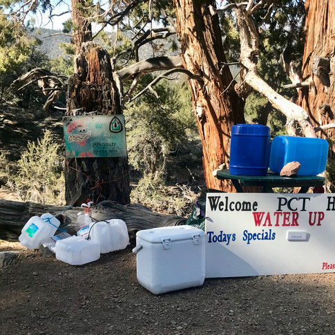
In addition to all the wonderful trails developed, promoted and maintained by the local Big Bear hiking enthusiasts, the Pacific Crest Trail (PCT) winds through Big Bear Valley. The PCT is a 2,650 mile trail through the states of California, Oregon and Washington. The trail is closely aligned with the Sierra Nevada and Cascade mountain ranges, which lie 100 to 150 miles inland from the Pacific coast. The trail's southern terminus is on the U.S. border with Mexico, just south of Campo, California, and its northern terminus is on the Canada–US border on the edge of Manning Park in British Columbia. People that hike the trail all at one time are called "thru-hikers" and take approximately 5 months for this effort. The PCT Association arranges for PCT Southern Terminus Hosts, which is similar to the program I've joined in Big Bear. Details about the Association can be reviewed by clicking here. The two photos below are of the hosts and a photo of a hiker on the beginning marker.
Click photo to enlarge. Use arrows to move to next photo


_______________________________________________________________________________________THE MOST CURRENT ACTIVITY IS FIRST BELOW________________
Friday, May 31, 2019
Spring Trail Evaluation - Service Road 2N01 to Service Road 2N02: Gerard Conijn, Art White and I drove to Big Bear Lake on Thursday, May 30th and stayed overnight at the Hadfield Cabin in the Moonridge area. The PCT from Onyx Summit to Highway 18 is 14 miles and is divided into three sections for purposes of the Spring Trail Evaluation. (A) shown on the map below is Onyx Summit at 8,531 feet elevation. From (A) to (B) is what I'm calling Section One and is 3.2 miles ending at Service Road 2N01. From (B) to (C) is Section Two and is 6.6 miles ending at Service Road 2N02. From (C) to (D) is Section Three and is 4.2 miles ending at Highway 18 at an elevation of 6,830 feet.

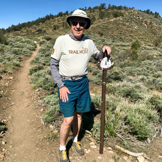
I have previously hiked and evaluated Section One (April 27th with Dale) and Section Three (May 3rd with Dennie). I convinced Art White and Gerard Conijn to join me in doing the evaluation of the middle section, Section Two. The Trail is close to the highway at Onyx Summit, so we began our hike there. This meant that I would walk Section One a second time since I had walked that section in April with Dale. Gerard, Art and I are shown below as we were beginning our hike.

We enlisted Art Harriman to assist us in getting to the beginning of our hike. I drove my car, and he followed us, to the parking lot where the PCT crosses Highway 18 - (D) on the map, which is about 8 miles from our cabin. I left my car there and we jumped into Harriman's camper to ride up Highway 38 to the beginning of our hike at Onyx Summit - (A) on the map (this is about 20 miles from where we left my car). The three of us were not sure the old camper was going to pull the steep highway up to Onyx, but we made it (Harriman was never in doubt). See photos below.
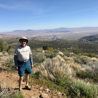
1st row: A view from Onyx Summit of Mount San Gorgonio (aka Old Greyback) covered with snow even though it's the last day of May. San Gorgonio is the highest peak in Southern California at 11,503 feet elevation; the PCT at Onyx is at 8,531 feet. The next photo is our delivery man, Harriman, who made the point that he is 77 years old and driving a '77 Dodge camper.
2nd row: The first photo is the three hikers with the camper, and the next photo shows water and supplies left on the Trail at Onyx by Big Bear residents who support the PCT hikers.
Click photo to enlarge. Use arrows to move to next photo


About a mile into Section One there was a fallen tree and some loose limbs on the trail that I had reported from my first evaluation. I sent in another photo just to remind the maintenance crew that it still needed to be cleared.

After walking the first 3.2 mile section we came to the beginning of Section Two that was the subject of todays safety evaluation for the boss (Bennett Rossell - Trails Coordinator). The photo below is me at the beginning of this section, identified on the map from (B) to (C).

In the early part of Section Two we came across a camping area called Arrastre Camp and stopped for a brief rest.
Click photo to enlarge. Use arrows to move to next photo


Section Two of the Trail, like the other sections I've seen so far, was in excellent condition and free of trash. There were, however, within the almost 7 miles of trail, a few places that needed some work. The first photo below shows a tree laying across the Trail that can easily be stepped over, but should still be removed. In the second photo the hill is quite steep above and below the trees laying length-wise on the Trail and with a heavy backpack like the thru-hikers carry, it could be awkward, and dangerous, to go along the Trail.
Click photo to enlarge. Use arrows to move to next photo


The two photos below show areas where water has accumulated from melting snow and it is awkward to cross - particularly if you were carrying a heavy backpack. Some flat stones would be a great improvement, but the water will probably be gone soon anyway, so I assume no maintenance will be needed.
Click photo to enlarge. Use arrows to move to next photo


This hike had a tough ending for me. About half-way through Section Two I began to have trouble with my left leg - difficult to explain, but it just wasn't working correctly. I wasn't getting a full stride and I was involuntarily leaning to my left. Later, my lower back began to hurt and as time went on it became very painful and made it difficult for me to walk. We decided I probably had a pinched nerve that was causing my problems. To my disgust and embarrassment, I was holding up my buddies from doing even an average pace. We had parked my car at the end of Section Three, which meant another 4.2 miles after the end of Section Two, and it became clear to me that I was in no shape to do the last section.
It was time for a minor miracle, and to my surprise, it happened. Without recounting all the details, we met a couple hiking the Trail, Jim & Debbie George, and Jim had parked his truck at the end of Section Two. Seeing that I was in trouble, he offered to give me a ride to my car from where his truck was. Thank goodness for Jim! I had hoped that Art and Gerard would finish the full hike as we had planned, but they decided to stay with me, so our hike was over at 9.8 miles instead of 14 miles.
This was a strange experience for me. After the ride to my car in Jim's truck, my back was feeling pretty good. I asked Art to drive us to the cabin, and then on down the mountain, in case my back acted up again. When we arrived home my back felt fine. I drafted this section of the blog on Sunday, after the Friday hike, and I still felt fine -- no back pain at all. Over the next couple of weeks after this blog was published I saw two different doctors. There had been no pain since the hike and they didn't think it was worthwhile to do an x-ray, MRI, etc. at this time. Since I have had some back problems in the past they agreed it could have been a pinched nerve as we thought, but said it could also have been a muscle spasm, which can be very painful and can be caused by dehydration. I'll just keep watch and be careful.
_______________________________________________________________________
Saturday, May 4, 2019
Spring Trail Evaluation - Highway 18 to Service Road 2N02: Dennie & Alison came to our cabin in Big Bear for a long-overdue visit and for Dennie to join me in exploring another section of the PCT. There are three sections designated for our Spring Evaluation between Onyx Summit and Highway 18 near Baldwin Lake. Dale and I explored the 3.2-mile first section going north from Onyx Summit (elevation 8,531 ft) to road 2N01 (elevation 7,899 ft) in April. The second section going north is 6.6 miles from 2N01 to 2N02 (6,782 ft). Where the PCT crosses road 2N02 is kind of in the middle of nowhere east of Baldwin Lake. I wasn't sure how I would get back to civilization from 2N02 after hiking 6.6 miles so I decided to hike the third section before the second section. This is a shorter 4.2 miles, going south from Highway 18 (6,830 ft) to road 2N02. This way the search to find our way back to town from 2N02 would be after a shorter hike. I'll do the second section at a later date.
Early Saturday morning I drove our car out to the last asphalt road east of Baldwin Lake and parked it there. Dennie & Alison followed, picked me up, and we drove to where the PCT crosses Highway 18; this was the beginning of our hike this morning. Alison dropped us off - we told her we would see her later, assuming we could find my car at the end of this PCT section.

The trail for this section was in excellent shape as can be seen in the photos below. There was just one situation that I reported for maintenance, which was a tree that had not yet fallen, but was leaning across the trail and would eventually fall. See the first photo with Dennie below. The next two photos are typical examples of most of the trail. The PCT hikers are very good about following the principles of "Leave No Trace" and "Pack it in, Pack it out" - I always carry a trash bag with me just in case we find something, but we found absolutely no trash along this section of the PCT.
Click photo to enlarge. Use arrows to move to next photo


There are a number of peaks and valleys along this section of the Trail. As we walked along one of high points of Nelson Ridge, at approximately 6,955 feet elevation, we had a great view of Lucerne Valley and the desert to the northeast. The first photo below shows how the cactus plants, normally seen in the desert below, began appearing in the mountains where we were walking. I didn't know the plant types but Dale told me later they are Joshua Trees. It was really interesting to see them among the more normal mountain vegetation.
Click photo to enlarge. Use arrows to move to next photo


Since we were hiking south, and the people hiking the PCT were all going north, we met and talked to over 40 hikers during the 4.2 miles we were on the PCT. They were all really friendly, happy, and enjoying what they were doing. I was a little surprised at how many hikers, both men and women, were single. Most were thru-hikers, i.e. had the objective of reaching Canada at the end of their hike, and all mentioned how much they appreciate the work done by the trail hosts along the Trail. The people in Big Bear are very friendly to the PCT hikers. Many hikers use Big Bear to stay in a motel and get a shower - the motels all give the hikers a discounted rate. At many places along the PCT as it winds through Big Bear Valley, the local folks place water and other supplies for the hikers. The photo below was taken about 50 yards from where the PCT crosses Highway 18. This is a common place for hikers to thumb a ride into town to stay overnight. There was water, a trash bag for them to unload things they were carrying, and eight cases of soda pop (two were beer). The pop was in the shade and was cold, so had obviously been placed this morning, not long before Dennie and I began our hike.

When we reached where the PCT crossed road 2N02 (i.e. the end of the section for us today), we began the search for a way back to my car in Baldwin Lake. I had been given some very general instructions by one of the people I met at the Trail Host Social the prior week. She said, "Walk a little ways back up road 2N02 and watch for a somewhat overgrown trail on the left. Take that trail and eventually you should run into a dirt road called Kickapoo. There will be other dirt roads going west and eventually they will lead to Baldwin Lake."
Those instructions weren't very precise, but they worked okay and after walking 1.8 miles we found my car. As we walked toward my car the area was covered with dirt roads leading to many cabins, homes, and what looked like small ranches. Whoever owns these places must have a strong desire to be alone! The first photo below was taken while we were still walking the PCT. It was very large, had it's own power windmill, and must have been at least 2 miles east of Baldwin Lake. The ranch in the second photo was located close to where we left the PCT and was named appropriately. The ranch in the third photo must be owned by someone with a good sense of humor.
Click photo to enlarge. Use arrows to move to next photo


_______________________________________________________________________
Saturday, April 27, 2019
Spring Trail Evaluation - Onyx to Service Road 2N01: When Bennett requested the Trail Hosts to sign up for a trail safety evaluation, I signed up for the PCT section from Onyx Summit to Forest Service Road 2N01. This section is about 3 miles in length, and then another mile on 2N01 west and up to Highway 38 to be picked up. My brother Dale and I decided to hike, and evaluate, this section on Saturday, April 27th and his wife Pam graciously agreed to drop us off at Onyx Summit and return later to pick us up along Highway 38.

The trail was in excellent shape. Although we took along a couple of trash bags, there was absolutely no trash left along the trail for us to carry out. The photos below show a few of the things we saw.
1st Row: The first photo is an example of how much of the trail looked; the second and third photos are examples of signage along the trail. The second photo identifies a Forest Service road at the point the PCT crosses, and also includes a sign making it clear that "Bicycles and Motorized Vehicles are Prohibited." The third photo is another sign, a PCT logo, that makes it clear you are still on the PCT.
2nd Row: The first photo is of a tree that has fallen across the trail and is an example of what the safety monitoring is all about. Situations such as this are reported and maintenance crews are sent to remedy the situation. The second photo is another example of markers along the trail to identify the proper trail. This is a 4X4 post with a PCT logo that is normally positioned in a place where a hiker may take a wrong turn. We found this post laying in the bushes and Dale is placing rocks at its base to insure it will stay in place. The final photo is an example of how the Forest Service Roads are identified. Road 2N01 was the end of the section we hiked today
Click photo to enlarge. Use arrows to move to next photo


Trail Host Social: The first Trail Host Social of this year was held on Saturday, April 27th at Aspen Glen Picnic area. I went to the Social, the first one I have attended, after cleaning up from the hike Dale and I had done. There were 20-plus Trail Hosts there, along with food and drinks brought in a combination of the individual hosts and the Host Program. They were a very interesting group of individuals, all dedicated to improving the trail system within Big Bear Valley. I met several individuals who were helpful to me as I tried to learn about some of the Forest Service roads that would take me back into the forest where I could find the PCT.
Bennett Rossell and Phil Hamilton spoke to the group about some of the coming activities and procedures that will help the overall goals of the Trails Programs. A very enjoyable couple of hours and I look forward to getting acquainted with more of the Trail Hosts out on the trails and at future Socials.
_______________________________________________________________________
Sunday, April 14, 2019 - My First Day as a Trail Host
Bennett sent out a request to all trail hosts to sign up to evaluate sections of the numerous trails within Big Bear Valley. I signed up to do the Spring Trail Evaluation of the first section of the Pacific Crest Trail (PCT) entering Big Bear Valley. That section begins at Onyx Summit and goes north into the valley in the Baldwin Lake area. Sunday morning I drove to Onyx Summit and located the PCT about 200 yards off Highway 38. As I arrived there were two women thru-hikers who had just been dropped off (one from Texas and one from Florida) and were about to resume their hike from the Onyx point.
Click photo to enlarge. Use arrows to move to next photo


Even though I hadn't planned to hike the trail this morning, I decided to walk the first mile because I was curious about the condition of the trail. The condition of the trail was excellent, but unfortunately I found quite a bit of trash. When I first entered the trail there was a place where someone had left plastic water bottles for the hikers (a good deed) but they were all empty and there was an accumulation of trash. A mile from there I found a container that was intended to hold supplies for hikers (apparently placed there by the Big Bear Hostel) but it had become a dumpster. I decided I would carry out the trash at the beginning point, but the dumpster was another story. I sent a photo to Bennett and suggested it might be a good idea to place the dumpster at the Onyx Summit point which would allow easier access for stocking and eliminating trash.
Click photo to enlarge. Use arrows to move to next photo


As I walked back south along the trail to Onyx Summit I met a surprising number of PCT hikers - most of them were "thru-hikers" - i.e. going the full distance from Mexico to Canada in one hike. I met over 20 hikers in that short section of the Trail - there were singles, couples, and groups of four, women and men, old and young. They were all really interesting people - in good spirits, and interested in stopping to talk a minute. I asked one of the single women if she was going the full distance on this hike - she said no, she was doing a section. I asked which section, and she replied "California" - I thought, wow! that's a big section! Without exception, the hikers couldn't thank me enough when they found I was a Trail Host. It made me feel good about what I was doing.
Back at Onyx Summit I gathered the trash and took to my car. At the highway I found one of the PCT hikers who was stopping for the day at the Onyx Summit point and was hitchhiking into Big Bear for the night. Of course I gave him a ride. He was from Oregon and hiking the full distance. After dropping him off in town I bought three large bottles of water and took back to Onyx to replace the empties I had taken away. As I was placing the bottles, two more hikers came along. They were from Pennsylvania and going the full distance. They were so excited to fill their bottles with what they called "filtered water".
Click photo to enlarge. Use arrows to move to next photo


I can't believe how much I enjoyed my first day as a Trail Host. I know I'm going to enjoy working the trails, meeting and helping hikers of all types ; PCT hikers, residents of the Valley, and tourists that come to the Big Bear from many locations to enjoy all the wonderful trails in the Valley.
_______________________________________________________________________
Comments