
HARLEY DAY-RIDE - RUNNING SPRINGS & OTHER MOUNTAIN COMMUNITIES
- Mar 8, 2018
- 10 min read
Police: "You were going fast."
Me: "I was trying to keep up with traffic."
Police: "There is no traffic."
Me: "I know. That's how far behind I am."
When I created my Updated Bucket List for YEAR 77 I listed a Harley day-ride on the 7th of each month. The idea was to ride to a place that had an interesting history and a fun route to ride on a motorcycle. On Wednesday, March 7th, I jumped on the Harley and headed for the small town of Running Springs in the San Bernardino Mountains. The morning was cloudy and cool in Monrovia, and forecast to be cloudy and cold in the mountains (which it was). Fortunately I took along my heated vest and gloves.
My plan was to ride a large circular route in the mountains, going through many of the small communities in the San Bernardino Mountains, then west to Cajon Junction on Hwy 138, then to Wrightwood in the San Gabriel Mountains and all the way west to La Canada on Hwy 2, the Angeles Crest Highway. Of course I had to ride some freeway to get to the mountains and home from the mountains, but the enjoyable part of the ride would be on fun, winding, mountain roads. This route is shown on the map below.

As it turned out, this ride was almost a "Mini-Iron Butt Ride." I left Monrovia at 7:30 am and arrived back home at 4:30 pm, a 9 hour ride. I know Dale and Dennie would have enjoyed this ride. The ride took a little longer than I planned because of a detour I had to take, and because of some ice on the road, which slowed me down (I like to drive a car on slick roads, but a Brodie on two wheels is a little dangerous). I'll comment on these situations as I cover some of the details of my tour.
Details of the Tour and a Little History of the Places Visited:
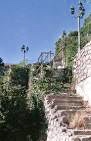
Running Springs- I chose to go up the mountain using what we call "the front way." This is east on the 210 freeway to the Highland area, then Highway 330 to Running Springs. The mountain roads are well-maintained, offer great scenery, and are fun to ride on a motorcycle. I arrived in Running Springs about 8:30 am, chose the Old Country Coffee Shop, and settled in to read the Wall Street Journal and have some breakfast. The big news this morning was that Trump's chief economic advisor, Gary Cohn, had resigned so I assumed the stock market would take a beating today. The photos below, from the left, show arriving at Running Springs; the small business district; the coffee shop where I ate; and the omelette I had for breakfast (I'm never going to lose weight eating these greasy spoon breakfasts).
Click Photo to Enlarge - Use Arrows for Next Photo


Running Springs is situated in the San Bernardino Mountains about 17 miles west of Big Bear Lake and about 8 miles south of Lake Arrowhead. Native Americans settled here first due to the many natural resources found here. They harvested acorns and herbs, but also hunted deer, rabbits and other wildlife. Running Springs was originally known as Hunsaker Flats, named for Abraham Hunsaker, an early member of the Mormon Battalion. The area was developed after improvements to the state highways in the 1920s. Snow Valley Mountain Resort was established here in the 1920s and was the first ski resort in the San Bernardino Mountains.
Skyforest- I left Running Springs going west on Hwy 18, known as the Rim of the World Highway, and in a few miles came to Skyforest where Sky Park at Santa's Village is located. This is a North Pole-themed outdoor adventure park nestled deep in the Lake Arrowhead area of the San Bernardino National Forest. Here they have various attractions, restaurants and shops in a historic log cabin village. They say Santa lives here year-round! During the holiday season, visitors can enjoy the magic of Santa’s Christmas Village when the Park is transformed into a WinterWonderland of fun for the whole family! During other times of the year tourists can experience the wonder of nature enjoying biking, hiking, fishing, archery, ziplining and climbing in the Northwoods. The first photo below is as I was on my way toward Lake Arrowhead from Running Springs - I think the peak with snow must be Mt. Baldy; the second photo is the main building at Sky Park at Santa's Village; next is a close shot of the main building which I intended to enter, but as shown on the sign, they are not open on Wednesdays; the last photo shows a few of the attractions from outside the locked gates.
Click Photo to Enlarge - Use Arrows for Next Photo


Lake Arrowhead- A few miles past Skyforest I turned on Hwy 173 at the Crest Park Picnic Area to go to Lake Arrowhead. They say that around 1826, the first white man to set foot in Lake Arrowhead (then known as Little Bear Valley) was a fur trader, who was a partner of Jedediah Smith. At that time, about 40 Paiute Indians, a warlike tribe, used the mountains for their hunting grounds. Later in the 1860s, the main attraction for the white man at Little Bear Valley was lumber, and cattle, and there were several saw mills in and around the Valley. The first road up the mountain was built in 1852 and called the Mormon Road. In the late 1800s the idea was hatched to build a reservoir to supply water to the southern lowlands. Many different businessmen and company's were involved over time, the construction of a dam was begun, and eventually the properties were acquired by a corporation that had conceived the idea of using the water for power. The Arrowhead Lake Company's plan was to develop the mile high man-made lake into a fine recreation and residential area, which they did. A village which included a dance pavilion, outdoor movie theater, restaurant, beach and bath houses was completed. Three hotels were built, and a 9-hole golf course was completed. Today, Lake Arrowhead is not only a popular recreational area for visitors, it is also a beautiful year round alpine residential community.
As I approached Lake Arrowhead Village I turned east and rode along the lake shore to Cedar Glen and to the North Shore on Hwy 173. There were several marinas along the way (most slips were empty of course) and there were many impressive large homes along the shoreline. The most impressive structure was actually the LDS Church, which I came upon completely by accident as I looked for a place to turn around. The first photo below is one of the marinas, and the next two are the LDS Church.
Click Photo to Enlarge - Use Arrows for Next Photo


I returned to the Village to look around and see if there were anything of interest (like an ice cream treat). Photos below from the left:
1st row- The first photo is the entry to the Village; the second photo is the first parking lost and group of shops you see as you enter; the third shows restaurants along the shore line.
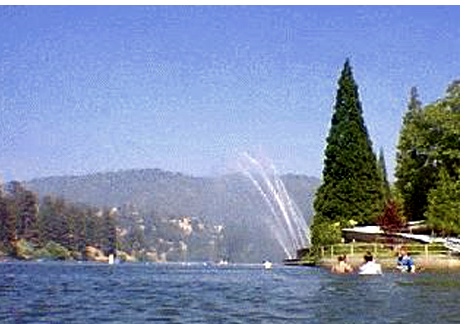
2nd row- The first photo is of the Directory of Village Shops - I counted 86 listed; the next two are images I found of the lake during summertime.
Click Photo to Enlarge - Use Arrows for Next Photo


Blue Jay- I left Lake Arrowhead Village on Hwy 189 and rode a couple of miles west to Blue Jay. This town started as the homestead of Art and Norma Wixom. They leased a few vacation cabins and opened a store in 1914. In 1934 Stoney DeMent leased the land and built a market called The Blue Jay Market. The store was named for the blue colored birds that live in the area, and this later became the name of the town built up around it. Residents began to move to Blue Jay about 10 years later. Blue Jay Village today is home to over 2,300 residents. It is considered the entertainment district of the Lake Arrowhead community. It contains a shopping center, a number of restaurants, and many privately owned stores. The village also hosts many events including the Lake Arrowhead celebration of film, The Blue Jay Christmas parade, and the Blue Jay Jazz Festival. The photos below just show the small Blue Jay business district.
Click Photo to Enlarge - Use Arrows for Next Photo


Crestline and Lake Gregory- From Blue Jay I rode through Agua Fria,Twin Peaks, and Arrowhead Highlands, three small unincorporated communities, on my way back to Hwy 18 and to the junction with Hwy 138, where I turned north toward Silverwood Lake State Recreation Area. Hwy 138 goes west of Crestline and Lake Gregory, which is a fairly large community (over 10,000 residents) and very active with visitors at the scenic Lake where they can enjoy fishing , boating, swimming, and waterslides. There are also many hiking and biking trails, and the Lake is ringed by a state-of-the-art fitness trail with exercise stations. Dale, Dennie and I have been in this community on some earlier Harley rides. I took the first photo of the valley below from Hwy 18 before I turned toward Crestline. The second photo is of Lake Gregory at Crestline.
Click Photo to Enlarge - Use Arrows for Next Photo


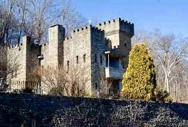
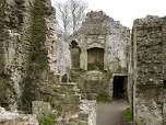
I didn't take the time to explore Crestline today because I have done that before. And more importantly, I was told there are ruins of an interesting castle in this area that I have never seen. I think I'll go back on another occasion to explore the area and find that castle. It is called Satan's Castle, aka the Devil's Castle. Rumor has it that many years ago the place was a known site of satanic rituals and human sacrifices. I found the photos of the castle shown below by researching on the internet, but I understand that ruins are still in the area.
Click Photo to Enlarge - Use Arrows for Next Photo
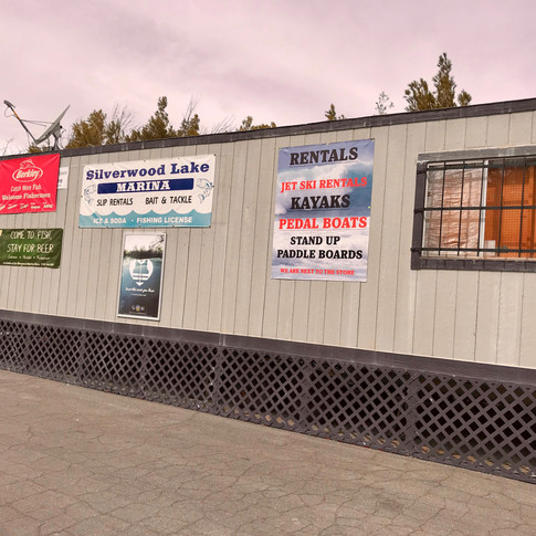
Silverwood Lake State Recreation Area- After passing Crestline it was a fun, steep, twisty ride down to Silverwood Lake. This lake is huge and is a very popular boating, fishing and camping location.

I was surprised that it was so far, 2.5 miles, from Hwy 138 on a road down to the marina. There were camping sites all along the way and a large parking lot at the marina. Very few people were there today - I guess being a cold cloudy weekday in March explains the lack of people. The marina rental & snack shop was just a double-wide trailer, but the picnic facilities along the shore looked very adequate.
Click Photo to Enlarge - Use Arrows for Next Photo


I left Silverwood Lake riding toward the Cajon Junction on Hwy 138. About 3 miles from the Cajon Junction I encountered my first big surprise of the day - there was a road closure manned by the CHP. The detour took me east, way out to Hesparia, then onto I-15, and back to Cajon Junction - a 22-mile detour.

Finally arriving at Cajon Junction, I continued north on Hwy 138, then west on Hwy 2, 17 miles to Wrightwood. Wrightwood is located in the Swarthout Valley, which was homesteaded by many men in the late 1800s and early 1900s. Sumner and Earl Wright were among them and eventually obtained two thirds of the land in the valley - this is where Wrightwood got it's name. Much of the land was used for the Wright's cattle ranch and apple orchards. In 1923, Los Angeles County established a major recreational facility at Big Pines, north of Wrightwood along Hwy 2 (the Angeles Crest Highway). The area began developing as a mountain resort as a result of a downswing in the cattle industry. The family started selling off parcels of land as subdivisions for summer resort residences. The Big Pines Recreation Area, now administered by the U.S. Forest Service, offers a variety of recreational opportunities and facilities for year-round enjoyment. Ten campgrounds and five picnic areas are available, and all provide tables, stoves and restrooms. Numerous hiking trails are in the area, including a section of the Pacific Crest Trail. Nearby Jackson Lake provides opportunities for fishing, and Grassy Hollow Visitor Center is just a few miles west of Big Pines. The very popular privately owned ski resort, Mountain High, is also near Wrightwood.
I arrived in Wrightwood about 1:30 pm and decided I should stop for a bite to eat. Having seen the Grizzly Cafe on prior trips to Wrightwood, but never stopped there, I decided to have lunch there today. It was a good decision. The owners, Leo and Debbie Hordyk, opened the Grizzly in 2003, and have done an outstanding job with the interior decoration and outside patio. And they have a great staff, providing good food and excellent service. I was so impressed with the staff that I gave my monthly $7 gift to one of the waitresses today. The first two photos below are me in front of the cafe and the cafe's main dining room. The first photo in the 2nd row is to show that I had a salad for lunch to average out my greasy spoon breakfast. The last photo shows a moose above the bar that has been automated. It moves it's head around slowly, and wiggles it's ears. It's a little unnerving - i.e. at first you're not sure you actually saw it move. I think the owners have a sense of humor.
Click Photo to Enlarge - Use Arrows for Next Photo


I left Wrightwood after lunch to complete my day-ride by taking the Angeles Crest Highway through to La Canada (about 52 miles) and complete the trip to Monrovia on the 210 freeway. This is where I encountered my second surprise of the day. Although it had been cold, and there was snow at the side of the roads all through the mountains I had been riding, the roads had been clear and dry. However, as I went into the higher elevations from Wrightwood I found ice on many curves in the road, where snow had melted at some point, run across the road, and then froze. This slowed my speed considerably. The photos below show the mountains I was heading toward. Next are a couple of shots of the road I was riding, taken just after a sign I passed that said, "Use Extreme Caution." The scenery was fantastic, but I had to concentrate on the road so much that I didn't enjoy this section of the ride as much as a passenger would have.
Click Photo to Enlarge - Use Arrows for Next Photo


As I said at the beginning, it was a long ride, but I enjoy long rides, and the scenery was exceptional. I only wish some of my riding buddies could have joined me. I stopped twice to eat, once for gas, and covered 232 miles during the ride. I plan to go back to Crestline one of these days, maybe when Dennie is back in town and riding with me, and find Satan's Castle.
=================================
P.S. The ride took me 9 hours - I hope it doesn't take 9 hours for someone to read this long blog - I apologize for the length.
Comments