
HIKING - PINEKNOT TRAIL TO GRANDVIEW POINT - OTHER HIKES IN THE SAN BERNARDINO MOUNTAINS
- Jun 10, 2018
- 7 min read
"Hiking is a bit like life. Enjoy the beauty along the way."
"It's easier to go down a hill than up it. But the view is much better at the top."
"Education is important, but hiking is importanter."
~Identity not acknowledged
Hiking the "Seven Summits of Big Bear" was an item on my Updated Bucket List and I accomplished those hikes in 2009 and 2010 (see A Little History below). But I wanted to do another hike in the San Bernardino Mountains during my YEAR 77 and Dale said he would be interested in joining me. Rather than do one of the hikes I had done before we checked a list of hikes at the Big Bear Discovery Center and decided to hike the Pineknot Trail to Grand View Point. This is a 7-mile round trip hike rated Moderate to Difficult. Below is the description of the hike from the Discovery Center's brochure:
The Pineknot Trail begins at the Aspen Glen Picnic Area and climbs south until it reaches the aptly named Grand View Point, altitude 7,784 feet (elevation gain of 900 feet). For the first 1 1/2 miles the hiker shares the trail with equestrian and mountain bike traffic, while they wind their way up through stands of white fir and Jeffery pine. Serious hikers make the round trip in 3 hours or less, while a family who plans to picnic at Grand View Point should plan on spending half the day to leisurely enjoy the forest, the mountains and a great view of Big Bear Lake.
Dale and I each drove to our respective cabins in Big Bear on Friday morning, June 8th. We had lunch at Mountain Munchie's and dinner that night at Maggio's Pizza. In between meals, Dale did his hiking warmup exercises preparing for the hike the next morning.
Click Photo to Enlarge - Use Arrows for Next Photo


Dale picked me up a little after 7:00 am Saturday morning and we drove to the Aspen Glen Picnic Area where the Pineknot Trail begins. It was a clear, cool morning and seemed perfect for a hike in the mountains. Beatrice, another hiker, took our photo at the trailhead and we began our hike about 7:30 am.

The trail was well-maintained and it was really an enjoyable walk through the forest. There was even a bench partway up the mountain to take a short correction of the elevation impact. And the scenery, looking upward and back toward Big Bear Lake, was beautiful.
Click Photo to Enlarge - Use Arrows for Next Photo


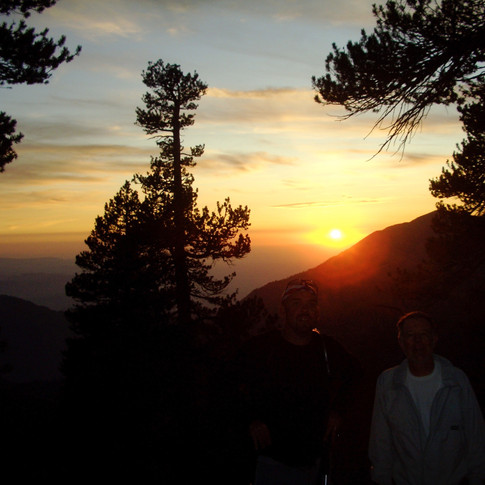
Although some of the literature had indicated that this was a 6-mile round trip hike, the signage on the trail said it was 3 1/4 miles from the trailhead to Skyline Trail, and when we reached Skyline Trail the sign said 1/4 mile to Grandview Point -- i.e. it is a seven mile round trip. We hiked at a leisurely pace and reached Grandview Point a little before 10:00 am. The third photo below shows us at Grand View Point with San Gorgonio Mountain in the background, and the fourth photo is looking down into the valley where the Seven Oaks Resort is located.
Click Photo to Enlarge - Use Arrows for Next Photo


We rested for a few minutes at Grand View Point, had a Power Bar, talked with a few other hikers and took some photos. A little after 10:00 we headed back down the trail.
Two Interesting Things on the Hike Down:
The Lightening Tree- On the way back down we noticed a "lightening tree" like the one behind our Big Bear Cabin where we have taken so many photos of family and friends. I couldn't resist having Dale take my photo to add to our Lightening Tree Collection.

Ryan Hall - First, a little background: Over the years that we have owned the Cabin in Big Bear, we have watched the running career of a young man named Ryan Hall. His dad was the track and cross country coach at Big Bear High School, and Hall excelled in the cross country events there, setting a number of school and state records. He attended Stanford University where he began running longer distances and set some records in the middle distance runs. In 2006 he won his first marathon in London, and won again the following year with the fastest time ever for an American there, 2:06:17. In 2008, Hall won the U.S. Olympic Trials Marathon in New York and went to the 2008 Summer Games in Beijing. This was very exciting for his supporters in Big Bear and the entire Bear Valley population got involved in showing their support for him with a running program called “Run, Ryan, Run.” I purchased a ball cap as part of the Support Ryan Program that said on the front of the cap, "Run, Ryan, Run". When Dale picked me up to go on the hike this morning he mentioned that he didn't bring a hat, so I lent him my red Run, Ryan, Run ball cap.
As we were walking back down the trail a man and woman were walking up and said to Dale as we passed, "Great looking hat!" I said, "Yes - I got it for supporting a local runner." The man said, "Yes, we know - we are his parents!" What an interesting coincidence that we would meet them on the trail. I asked how Ryan was doing and his dad said he wasn't running competitively now, but was coaching his wife and son in distance running. Then he said that Ryan now weighs 190 pounds! That's hard to believe - he weighed about 150 when he was running. Ryan had a great running career. He placed 10th in the Beijing Olympics. In 2011 his time in the Boston Marathon was 2:04:58, the fastest time ever for an American, not only for Boston, but in any marathon. Unfortunately Boston was won by a guy from Kenya with a time of 2:03:02. Anyway, I really enjoyed the short conversation with his parents on the trail.
We were back at the Aspen Glen Picnic area about noon. We felt we had an enjoyable hike and a fun time in the mountains. We agreed we should do some more hiking in the Big Bear Valley in the months to come. There was a trail junction near Grand View Point with a sign saying it was 2 1/4 miles on trail 0E01 to Seven Oaks Resort. We're thinking our next hike might be the Pineknot Trail to Seven Oaks if we can talk Pam and Bonnie into meeting us with a car at Seven Oaks. We'll see!
A Little History- Hiking in the San Bernardino Mountains: During 2009 I joined with a hiking group in Big Bear Lake and hiked what they had designated as "The Seven Summits of Big Bear." There were six hikes within Bear Valley that we hiked on weekends during May, June, July and August. Each of the hikes were quite different in terms of the condition of the trails, the distance, the steepness, and the surrounding forest environment. The individual hikes, including the elevation of the trailhead and summit, were: Bertha Peak - 6,804 ft to 8,201 ft; Grays Peak - 6,750 ft to 7,920 ft; Gold Mountain - 6,870 ft to 8,235 ft; Sugar Lump/Bear Peak - 7,300 ft to 8,805 ft; Delamar Mountain - 6,860 ft to 8,398 ft; and Sugarloaf Mountain, (the highest of the six) - 7,400 ft to 9,952 ft. The seventh peak was an overnight hike of San Gorgonio Peak, in the valley to the south, during September. The photos below of the first six hikes from the left: 1st row- The full group ready to hike Bertha Peak; the group at the summit of Gold Mountain. 2nd row- the four of us (and Chief the dog) that hiked Sugarloaf Mountain; me at the summit of Sugarlump/Bear Peak. 3rd row- A rocky slope going up Bertha Peak; and a view of Big Bear Lake from one of the northern peaks with San Gorgonio visible in the next valley to the south.
Click Photo to Enlarge - Use Arrows for Next Photo


San Gorgonio (also known as "Old Greyback") is the highest peak in Southern California at 11,500 feet and 7th highest in the U.S. It's 12 miles to the summit from the trailhead with over 4,000 feet of elevation gain. It was a good adventure with a fun group of hikers from the Big Bear area. We hiked to the summit the first day, then a short distance back down to where we made camp for the night. Photos from the left: 1st row- The full group at the trailhead; me at the sign at the trailhead. 2nd row- three of us on our way up the mountain - this was the toughest hike of the seven since we carried full packs with overnight camping gear; next is those of us that made the summit. 3rd row- the first photo shows that it got dark as we went back down to where we made camp; the final photo is breakfast the second day in our not so comfortable camp site.
Click Photo to Enlarge - Use Arrows for Next Photo


When I hiked the Seven Summits of Big Bear in 2009, there had been a huge forest fire the prior year and because of fire damage, Butler Peak, which was originally one of the Seven Summits, was closed to hikers. In 2011 Butler Peak was put back on the list and I joined a group that hiked it during August of that year. Butler Peak is a 12 mile round trip going from 7,100 feet at the trailhead to 8,535 feet at the peak.
Photos below: the fire lookout shack at top of Butler Peak, and Art & I at the top of Chair Seven at Snow Summit.
Click Photo to Enlarge - Use Arrows for Next Photo


Comments