
HIKING - THE GRAND CANYON - SOUTH RIM / PHANTOM RANCH ROUND TRIP
- Apr 14, 2018
- 19 min read
"The world is big and I want to get a good look at it before it gets dark."
~ John Muir
"The best view comes after the hardest climb."
"My legs are hungover!"
Hiking the Grand Canyon was one of the main items on my Original Bucket List. My YEAR 77 seemed like the appropriate year to finalize a plan to finally clear my bucket list of this item.
Bonnie & I spent the 2007 New Year's holiday at the South Rim with our group of Utah friends and stayed at the wonderful El Tovar Hotel. And I've been to the South Rim and the North Rim on motorcycle trips. I had thought about doing the "rim to rim" hike, but as I talked with various people about the trip it seemed like doing this would be awkward in the sense that it would be best to have someone to drop you off at one side of the Canyon and pick you up at the other side. I know there are shuttles that perform this service, but I wasn't sure that would be the best.
I recruited Art, Gerard, and Harry to join me and we began making plans. Eventually we decided to hike down the South Rim, stay a couple of nights at the Phantom Ranch at the bottom of the Canyon, do some exploring one day at the Canyon bottom, then hike back up the South side. I wanted very much to stay at the Phantom Ranch where you can sleep in a bed and they have a cafe of sorts. Besides being more comfortable, this eliminates packing all the camping materials up and down the canyon. We were told that the Phantom Ranch is small and fills up quickly. The soonest they allow reservations to be made is the first of the month that is 12 months earlier than your hike date. The four of us agreed we would do our hike early April 2018, so on April 1, 2017 I called the Reservation Service and made arrangements for our beds and all meals while we will be there, including a lunch to carry back up the hill on our climb out of the canyon.
BRIEF OVERVIEW:
The Trip - We drove in Gerard’s SUV to Grand Canyon Village on Monday, April 9th and stayed overnight at the Maswik Lodge. Tuesday we hiked 7 miles down the South Kaibab Trail to the Phantom Ranch. We stayed Tuesday and Wednesday nights at Phantom Ranch, doing an easy hike and relaxing during the day Wednesday. We hiked out of the Canyon Thursday on the 10-mile Bright Angel Trail and stayed that night at the Maswik Lodge. Friday (the 13th) we drove home - an uneventful eight hour drive. My Evaluation - I will provide more detail below than most readers will care to read, so here is my overall evaluation. The four of us agreed that it was a wonderful experience. The immense size of the Canyon, particularly when you are below the rim, is overwhelming. We tried to capture the size and beauty with photos and hope that some of them will serve that purpose. We met some really interesting people and were truly impressed by the knowledge, skill, and devotion to duty of the Phantom Ranch staff and the Park Rangers. We were told that over six million people visit the Grand Canyon each year and that only 1% of them make the round-trip trek to the bottom of the canyon and back. That made me feel proud to have done it. Art, Gerard, Harry and I got along great for the five days we were gone and I really enjoyed everything about the trip. I'm happy to have accomplished the hike and to be able to check the Grand Canyon Hike off my Bucket List. MONDAY - DAY ONE:
We met at my house about 7:30 am on Monday, April 9th, and we got on the road about 8:00 am with Gerard driving his SUV. The weather was nice and the drive uneventful. We stopped in Kingman, AZ for gas and a quick lunch, and drove on to the Grand Canyon Village, arriving about 3:30 (it’s a 475-mile drive).
We checked into the Maswik Lodge, which is named after a Hopi Kachina who is said to guard Grand Canyon. It consists of a main lodge that houses the Registration, Gift Shop, Food Court and Pizza Pub, and a series of two story lodging units. We were assigned to the Cottonwood Building where we found the rooms to be very nice. Harry and I roomed together and to my surprise, my room number was 6777. As many readers know, I have been obsessed with sevens, and how often they continue to pop up in my life. We walked over to the Bright Angel Lodge where we had to check in and confirm our reservation for the Phantom Ranch. We learned a lot at check in that we wished we had known before. Primarily the weather was what surprised us (even though we should have known). The weather forecast at the bottom of the canyon was much warmer than we had anticipated - even hot. We had all brought too much clothing, but we were able to repack and leave some things in the car.
We had a good dinner at the Maswik Lodge cafeteria, and hit the sack to get a good rest before the hike on Tuesday morning. The photos below show our arrival at the Maswik Lodge and a brief walk along the rim near the Bright Angel Lodge. The second photo is the four of us - Art, Gerard, Harry and me.
Click Photo to Enlarge - Use Arrows for Next Photo


TUESDAY - DAY TWO:
The Trail - The South Kaibab Trail is the shortest route from the South Rim to the Colorado River, and provides direct access to the Phantom Ranch at the bottom of the Canyon. The trailhead is located south of Yaki Point, about a 1/2 hour ride by shuttle bus from the Village - no private vehicles are allowed. The trailhead elevation is 7,260 feet. Stops along the way include: Ooh-Aah Point at 1 mile, a drop in elevation of 600 feet, with a spectacular view; Cedar Ridge at 1.5 miles, a total drop in elevation of 1,140 feet and a suggested turn-a-round point for first time canyon hikers; Skeleton Point at 3 miles, a total drop in elevation of 2,060 feet and the first view of the Colorado River. It is suggested hikers do not go beyond this point on a day hike; The Tipoff at 4.6 miles and a total drop in elevation of 3,390 feet; and the Kaibab Suspension Bridge at 6.4 miles and a total drop in elevation of 4,860 feet. The South Kaibab Trail ends at the River and the North Kaibab Trail begins on the far side of the the bridge and continues on another 0.9 miles to the Phantom Ranch for a total hike distance of 7.3 miles.
The Park Service cautions hikers in many published documents that include the following information: (1) The steepness of the trail is very misleading on the way down; plan on taking twice as long to hike up as it took to hike down. (2) Everyone needs to carry water. There is water available at the trailhead year-round, but no water available on the trail. (There was no water available at the trailhead the day we hiked). Lacking water and shade, the trail can be brutal. Half a dozen hikers have died from the effects of heat and dehydration along the trail, and many more have collapsed. (3) Remember to eat as well as drink while hiking. (4) To ensure your safety, step off the trail on the uphill side when mules are passing. (5) Go slowly, rest often, stay cool. Depending on how prepared you are, your trip can be a vacation or a challenge, a revelation or an ordeal. Over 250 people are rescued from the canyon each year. The difference between a great adventure in Grand Canyon and a trip to the hospital (or worse) is up to YOU.
Brief Trail History - Archaeologists have excavated a 900-year-old Pueblo near the Kaibab Suspension Bridge. The prehistoric site consists of five connected rooms and a separate round ceremonial room. When John Powell landed along the river near the site in 1869, he noted the ruins and old trails nearby. He reported finding "broken crockery," but over the years it has disappeared. In the late 1880s, prospectors capitalized on the growing tourist trade and staked out claims for the sole purpose of controlling the few trails in the canyon, mostly old American Indian routes. The Bright Angel Trail existed at that time, and for many years there were tolls collected for the trails use. The Park Service was determined to establish control of the inner canyon and began constructing a trail from the western side of Yaki Point in December 1924. One crew worked up from the bottom and one crew down from the top. They met in June of 1925, linking the upper and lower sections of the trail and linking with the North Kaibab Trail across the river giving access to the Phantom Ranch.
Our Hike In To Phantom Ranch - We went to the pickup point for the shuttle bus to the South Kaibab Trailhead at Yaki Point at 8:00 am. The shuttle was a little late and we didn't get to the trailhead to begin the hike until around 9:00 am. Photos below are the four of us waiting for the shuttle, Art showing off his spats (his solution to keep small rocks out of his shoes), me at the trailhead, and a view of the canyon from the trailhead.
Click Photo to Enlarge - Use Arrows for Next Photo


I've wished I had a Geologist along with me on many hikes, and that was certainly true on this one. A hike along the South Kaibab crosses more than a dozen geologic formations. As you descend the trail, the rocks increase in age from 270 million years old at the rim to 1.7 billion years old at the river. The many different rock layers are obvious as you drop in elevation (sandstone, limestone, etc), but what all the layers are, and what they mean, is beyond me.
The trail abruptly leaves the plateau, zigzagging through rock ledges in a steep descent known as The Chimney. All of the trail information I saw in my research before the hike emphasized that it is steep, zigzags with tight switchbacks, descends 4,800 feet (trailhead to the river), and the difficulty should not be underestimated. I never saw a warning, or even a mention, of the constant stair-steps, which made going down significantly more difficult (at least for me they did). The first photo is as we entered the trail, next shows the type of steps that were on a majority of the trail distance, the third photo is a little further down the trail, and the final photo is a look over the edge into the gorge below.
Click Photo to Enlarge - Use Arrows for Next Photo


We continued down the trail stopping briefly for a breather at Cedar Ridge (1.5 miles) and at Skeleton Point (3 miles). The photos below from the left: 1st row- Resting at Cedar Ridge; looking at what's below from Cedar Ridge; and some mule riders coming up the trail. 2nd row- Having a rest at Skeleton Point; our first view of the Colorado River which seemed close in one sense, but we were not yet half way there; and the final photo, if you look closely, shows the trail below zigzaging down toward the river, and changing from a red color to white as it moves into different rock formations.
Click Photo to Enlarge - Use Arrows for Next Photo


When we had hiked what seemed like quite a ways passed Skeleton Point my legs were getting weary and we approached a sign that I hoped it would say something like 2 miles to Phantom Ranch, but we still had 3.8 miles to go.

The trail continued it's steep descent with constant stair-steps until reaching a brief plateau called the Tonto Platform where the Tonto Trail crosses the South Kaibab Trail. This junction is called The Tipoff, after which the trail plunges downward again, with the last set of switchbacks leading to a short tunnel and the black Kaibab Suspension Bridge. My legs (the quads) were shot at The Tipoff and I told the other guys to go ahead -- that I would go much slower the rest of the way. Gerard and Art went ahead, but Harry stayed with my slower pace and we reached the Ranch a while after the other guys. I believe my time on the trail was about 5 1/2 hours. Photos below from the left: 1st row- One of the few bright flowers I saw on the trail; Me and Harry at the river - the tunnel behind us leads to the bridge. 2nd row- The Suspension Bridge, which is essentially the end of the hike; and Harry getting a rock out of his shoe on the other side of the bridge. I guess he could have used spats like Art wore.
Click Photo to Enlarge - Use Arrows for Next Photo


The Phantom Ranch - In the 1920s, the National Park Service selected the Fred Harvey Company to build a tourist facility within the canyon. Mary Jane Colter was commissioned to draft the plans for the facility and she chose the name Phantom Ranch, against the wishes of the Park Service, who wanted the name "Roosevelt's Chalet." The rustic cabins and main lodge are built of wood and native stone, blending with the natural beauty of the setting. Phantom Ranch covers only fourteen acres within the National Park that extends for almost 2,000 square miles.
Staying at the Ranch in the bottom of the Grand Canyon is a must-do for all outdoor adventurers! It's not a true ranch in the sense of cattle roaming open fields, but it is full of the spirit of the old west. The Ranch is a world unto itself, isolated, with unspoken rules, unique personalities of long-time staff members, and a constant supply of canyon-lovers. The buildings are all stone and wood with a similar, very attractive, mountain-style appearance. We checked into Cabin #10, which was about 150 square feet large, having two bunk beds, a sink and a toilet room (there was a separate building with multiple shower stalls). I had reserved a cabin specifically back on April 1, 2017 in order to have the four of us together. The alternatives were either a dormitory with a bunch of other hikers (first come/ first choice of the beds), or outdoor camping. Tuesday evening we had our first experience at the Canteen for dinner. All meals (breakfast, lunch and dinner) must be arranged in advance (again, we made these arrangements in April 2017) and groups of 44 are served “Family Style” during a 50 minute period (i.e. the main entree, salad, drinks, etc. are on the table to be passed around to everyone as needed). The food was delicious and the conversation around the table was interesting. The photos below are of our Cabin #10 and the evening meal in the Canteen.
Click Photo to Enlarge - Use Arrows for Next Photo


Before leaving the Canteen after dinner, one of the hikers stood up and introduced Bill & Neva, a couple they had met during dinner, who had hiked the Grand Canyon over 100 times. Later, outside the Canteen, we chatted with Bill & Neva and they were an interesting couple. Bill was 81 years old and had hiked the Grand Canyon 108 times in the last 20 years. His wife Neva was about to turn 80 and had hiked the canyon 105 times. They were from Prescott, AZ and told us some interesting stories about their experiences and the many other places they had hiked. I wanted to take a photo of them, but it was too dark at that time. The following morning, while I was outside the Canteen having a cup of coffee before breakfast, I met the couple that had introduced Bill & Neva the night before - Mark & Corinne from San Antonio, TX. They were also an interesting couple, and since Mark had retired early they were doing many interesting things like the hike into Grand Canyon. They mentioned that they had taken a photo of themselves with Bill & Neva, and Mark kindly forwarded a copy to me which I've shown below. From the left, Mark & Corinne's hiking friend, Mark standing behind Corrine, Bill, and Neva.

WEDNESDAY - DAY THREE:
The Mules - After the "Late Breakfast" ("late" is at 6:30 am at the Ranch) we enjoyed watching the mule trains come in from the South Rim. The wranglers told us that they leave the top about 5:00 am and come down the South Kaibab trail in about 2 1/2 hours. The mules can carry duffels weighing as much as 200 pounds for campers, hikers, and supplies for the Ranch. They return to the top in about 3 1/2 hours, giving the mules a few periods of rest on the way up.
Photos from the left. 1st row- Art having coffee at his favorite bench outside our cabin; the arrival of the first mule train; the guy wrangler securing his mules. 2nd row- The woman wrangler arriving; a view of one of the leather bags carried under the canvas coverings on the mules; and finally, Art and Gerard trying to have a conversation with one of the mules.
Click Photo to Enlarge - Use Arrows for Next Photo


Our Short Hike - After breakfast we decided to take a short hike to shake the stiffness from our legs from yesterdays hike. The North Kaibab Trail leaves the Ranch following the Bright Angel Creek toward the North Rim. This was a wonderful walk alongside the creek in a beautiful canyon and in perfect weather to be outside.
Click Photo to Enlarge - Use Arrows for Next Photo


As we were walking up the trail, a young couple passed us running up the trail and we talked to them for a few minutes. They had run down the South Kaibab Trail that morning, were doing a short run up the canyon because they had heard it was beautiful, and were then going to run up the Bright Angel Trail, returning to the South Rim where they had started that morning. If you have seen these trails up and down the Canyon you know this task is very impressive. Their photo is below.

Further up the trail we met three young women taking a rest along the trail. They were carrying full camping gear and said they were from Toronto and had been training for months to come to the Grand Canyon and do the “Rim to Rim” hike. They said unfortunately they hadn’t realized how tough coming down South Kaibab would be and they didn’t make it to the river campgrounds until 7:30 pm the prior day which put them behind schedule. Part of their problem had been the same problem I experienced. They had trained for steep downhills, but not the high stair-steps that killed their quads. Their new plan was to go part way to the North Rim, camp out at an area called Cottonwood, then turn around and go back up to the South Rim where they had begun. It was fun talking with them, they were still enthusiastic and said they were having a ball.

The Park Ranger - At 4:00 pm and again at 7:30 pm one of the Park Rangers gave a presentation in an open-air setting on the grounds of the Ranch. The Ranger was so enthusiastic in her presentations you couldn't help but enjoy them. The 4 o'clock presentation was about the geologic history of Grand Canyon. She had prepared a handout that showed all the changes that have taken place in all of history, and she then related the time of those changes to a 12-month calendar. This gave an interesting perspective on how long a billion years is. The changes that I could relate to, as an example, all took place on her illustrative calendar on December 31st at 11:59 pm. In the evening presentation she basically answered questions from the people attending. There were many interesting subjects covered. An example, and one that interested me, had to do with access to potable drinking water for the Grand Canyon facilities. The water from the Colorado River is allocated under a complicated agreement among seven states the Colorado river and its tributaries pass through on the way to Mexico. There is no allocation included for the Grand Canyon or the Park Service. There is a spring named Roaring Springs about half way up the North Kaibab Trail where all the water for the Canyon is accessed. We saw the pipe coming down the trail and creek when we went for an easy hike on Wednesday morning. She said in addition to supplying the water for the Ranch at the bottom of the canyon, the water is carried about half way up the South Rim by it's momentum, or the siphon affect, where it reaches a pump house. The photos below show the afternoon Park Ranger gathering, and the pump house at Indian Garden about halfway up the Bright Angel Trail (we saw this on our hike out on Thursday). I've included a photo of the plaque describing how the system works to serve the canyon as a matter of interest - it's too small to read in this blog.
Click Photo to Enlarge - Use Arrows for Next Photo


THURSDAY - DAY FOUR:
The Trail - The Phantom Ranch is located on the North Kaibab Trail, which goes north up to the North Rim. However, if you are hiking out to the South Rim you begin by going south on the North Kaibab Trail, through the Bright Angel Campground to the Silver Bridge on the Colorado River, and then follow the River Trail to the River Trail Junction. This is a 1.9 mile section of trail, ending where the Pipe Creek enters the Colorado River and where the River Resthouse is located. You catch the Bright Angel Trail at the junction and begin climbing along side the Pipe Creek to the Devils Corkscrew, where the trail goes westerly to the Garden Creek, where the trail resumes its southern direction along the Creek up to Indian Garden. From the River Trail Junction to Indian Garden is a 3.1 mile section. From Indian Garden to the Three-Mile Resthouse is 1.6 miles, including a set of difficult switchbacks called Jacobs Ladder, and another 1.5 miles to the Mile-and-a-Half Resthouse, and 1.5 miles to the South Rim. The names of the last two resthouses are distances from the top, not the direction we hiked from Phantom Ranch. Distances and elevations are different in many books, pamphlets, signs, etc. The trail guide I used shows the total hike from Phantom Ranch to the South Rim at 9.6 miles, and the elevation gain from the river to the top of 4,460 feet.
Brief Trail History - For hundreds of years humans have traveled along the Bright Angel Trail. The two reasons for this being one of the earliest and most used trails from the South Rim are water and accessibility. The springs at Indian Garden produce more potable water than others along the south side of the canyon, and the Bright Angel Fault creates a natural break in the cliffs, making it relatively easy to reach those springs. Both prehistoric and historic American Indians used the trail and raised crops along Garden Creek. (I loved the scenery and atmosphere when hiking along the Garden Creek). Miners began using the route in the late 1800s and operating it as a toll road. They maintained control for many years by filing dubious mining claims at points along the trail. The Santa Fe Railway filed suit challenging these claims and after much litigation the claims were finally invalidated in 1920.
Our Hike Out To The South Rim - We had previously arranged for a 5:00 am breakfast at the Canteen, and for sack lunches to be available at that time. We began the approximate 10 mile hike out to the South Rim via the Bright Angel Trail at 6:00 am.
A side note to the hike out: On Tuesday, when we hiked the South Kaibab Trail in to the Phantom Ranch, my legs (the quads) were absolutely shot by the end of the hike. I had noted that one of the Ranch Services allowed people to send their backpacks up the trail by mule. I decided to “cheat" and do the same with my backpack for our hike out. My legs were fine on the hike out and I think I would have been okay carrying the backpack, but I wanted to guarantee that I would enjoy the hike.
We went south from the Ranch along Bright Angel Creek, passed the Bright Angel Campground, and crossed the Colorado River on the Silver Bridge. Photos below show Harry and Art getting ready to leave our cabin about 6:00 am, next is the Bright Angel Campground as we passed by, then the Silver Bridge as we approached, and lastly a sign explaining that the Silver Bridge serves two primary functions - as a crossing for hikers and as a support for the transcanyon waterline.
Click Photo to Enlarge - Use Arrows for Next Photo


Once across the river we went westerly along the River Trail. The Civilian Conservation Corps (CCCs) constructed the River Trail between 1933 and 1936 to enable hikers and mule riders to reach Phantom Ranch from the Bright Angel Trail. The first photo below is looking back at the Silver Bridge with a river raft passing beneath; the second photo shows that the River Trail passes through a sand dune habitat; and the final photo is of the River Resthouse, built by the CCCs in 1936, located at the River Trail Junction.
Click Photo to Enlarge - Use Arrows for Next Photo


The first photo below shows us walking along the Pipe Creek as we begin the climb up from the river; the second photo was at a rest stop and Harry decided to see what kind of animal was hiding in a cave across the creek from us; the third photo is much higher, after we have been through the Devil's Corkscrew; and the final photo shows Art walking along a solid rock path next to the Garden Creek - one of the really pretty areas of this trail.
Click Photo to Enlarge - Use Arrows for Next Photo


Indian Garden is about one-half way to the South Rim from Phantom Ranch and is a main rest stop for most hikers. There are benches in the shade, potable water, and clean restrooms. There is also a Ranger Station, although I'm not sure if it is always staffed. We stopped here for our lunch. Indian Garden has long been a focal point for human activity in the Canyon. Groundwater seeping through the rock layers above is stopped by the impervious Bright Angel Shale and comes out here in several springs. These springs were first used by prehistoric humans, and after AD 1300, the Havasupai Indians farmed the area seasonally. More recent use has centered around mining and finally tourism. The first photo below is a welcome sign with information about what is located at this site; the next two photos are just of the buildings and the rest area; the last photo is of Art and Harry getting ready to leave the area.
Click Photo to Enlarge - Use Arrows for Next Photo


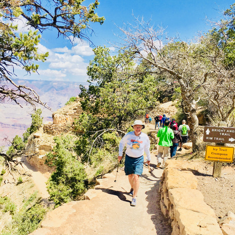
The first photo below looks back at a steep zigzag climb as we neared the top. The second photo is of the Mile-and-a-Half Resthouse. The third photo is simply a scenery shot as I was near the top of the Rim; and the final photo is of me coming to the "finish line" - i.e. the end of the Bright Angel Trail. I didn't get photos of the other guys "finishing" because Art and Gerard were already at the top when I arrived, and Harry was still a little lower searching for some Petroglyphs the Park Ranger had told us about during Wednesday's presentation.
Click Photo to Enlarge - Use Arrows for Next Photo


The Evening - When we reached the top of the South Rim it was very windy and cold. We finally had cell service, so we all called our wives and told them about our great experience and that we were safely out of "the big hole." (I also sent a text to my three favorite daughters). Then we headed for the Maswik Lodge to check in, have a drink, and get warm. I should make mention for those readers who know Harry - when I talk about us having an adult beverage, Harry's adult beverage is always water. Later, after we all had showered, we took a walk over to the El Tovar Hotel to look at this fine old hotel and have an adult beverage, and then returned to the Maswik Lodge for dinner and an early bedtime.
FRIDAY - DAY FIVE:
A very uneventful day, as the last day of a fun trip usually is. We had breakfast at 6:00 am at the Maswik Lodge Cafeteria and were on the road at 7:00 am. We stopped for gas in Ludlow, CA and each of us grabbed something to eat at the Dairy Queen within the service station. I had a Blizzard, which I love but try not to have very often. We were in Monrovia some time around 3:00 pm, congratulated each other on a successful hike and fun week, and all went our separate ways. The four of us will definately do some hiking together again.
Comments