
HIKING - THE BRIDGE TO NOWHERE
- Oct 8, 2017
- 4 min read
"I love places that make you realize how tiny you and your problems are."
When I prepared my Updated Bucket List I researched in the book, Trails of the Angeles, to list a number of hikes in the San Gabriel Mountains that I would like to do. My YEAR 77 seemed like the appropriate year to clear The Bridge to Nowhere off the list. Just the name, The Bridge to Nowhere, requires a person to look into this hike further. Briefly (see A Little History below for more detail), the bridge is about 25 miles into the San Gabriel Mountains northeast of the town of Azusa, and sits all alone spanning the East Fork of the San Gabriel River. It's a 120-foot high arch bridge built in 1936 and was part of a road that was to connect the San Gabriel Valley with Wrightwood. The road was washed out in the Great Flood of 1938, leaving the bridge stranded in the middle of the Sheep Mountain Wilderness. It is also the only place in California where bungee jumping is allowed. I lifted the photo below from the internet.

Early on the morning of October 7, Tracy, Art, and I drove up Azusa Canyon on San Gabriel Canyon Road about 12 miles, then went on East Fork Road for about 6 miles to reach the trailhead of the Bridge to Nowhere. We planned the hike on a Saturday specifically because bungee jumping is allowed on weekends and we were interested in watching this activity (and I thought maybe Art would decide to jump). The photos below are at the trailhead at about 7:30 am and at Camp Williams for a drink after the hike at about 2:00 pm. It was a fun, scenic, and very interesting day. They say the round-trip hike is 11 miles with an elevation gain of 2,113 feet. We were hiking about 5 hours and we spent 1 1/2 hours at the Bridge. I was tired at the end of the hike, and I assume Tracy and Art were as well.
Click Photo to Enlarge - Use Arrows for Next Photo


The Hike: This was an extremely interesting and scenic hike, up a narrow canyon following the East Fork of the San Gabriel River. The hike features multiple river crossings (including opportunities to swim). In the spring, they say the water can run fast and deep, sometimes being waist high. Another interesting feature of this hike is that there are also multiple trails. There were many other hikers on the day we did the hike and although everyone generally followed the riverbed up the canyon, we could always see other hikers on a different trail than we were on. My guess is that these trails have developed over the years depending on the time of year and the depth of the river where hikers make their crossings. The trails were quite varied; some dirt trails through various types of growth, some very rocky, some very narrow, and some transitions through some tricky rock formations. And there were several river crossings. The photos below illustrate some of this variety. Periodically there were visible sections of the old asphalt roadway that was abandoned after the 1938 flood. I call the bridge below in the second photo The Bridge to the Bridge. Eventually you reach the Bridge to Nowhere, which is an odd but beautiful sight.
Click Photo to Enlarge - Use Arrows for Next Photo


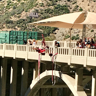
The Bridge: As we approached the Bridge my first impression was that it was very cluttered. Unlike the photo at the beginning of this blog taken from the internet, there were many hikers and all the paraphernalia related to the bungee jumping activity. In addition to seeing the Bridge, we stayed long enough to have a snack and watch some of the crazies jump off the bridge. The photos below from the left:
1st row - As we approached the Bridge from the trail; from the other end of the Bridge (with Art and Tracy the small figures on the right); Art and Tracy on the Bridge from closer. 2nd row- Me on the east end of the Bridge; a young woman getting ready to jump; and as she jumps. 3rd row - First two photos are the same young woman during her jump, but photos don't do the action justice; last photo shows another young woman going off the Bridge in a dive rather than a jump.
Click Photo to Enlarge - Use Arrows for Next Photo


You can copy the URL below and paste it in your browser to see the video I took of an actual jump while we were at the Bridge.
https://youtu.be/jigQ79lBRt4
Bungee Jumping: For anyone interested, the private company Bungee America that provides the bungee jumping activity can be found at http://www.bungeeamerica.com/bungee/
The website begins: "Welcome to the most adrenaline filled adventure in Southern California. You are about to become part of a small minority who can say they have jumped of a bridge connected to a giant rubber band!" Of course, that's what we all want to be able to say! The single jump packages are $99, which allows you to perform one bungee jump with a full body harness. You can choose either the Superman Front Dive or the Backwards Plunge. Each additional jump is $50.
A Little History: The East Fork Road was still under construction when it was washed out during the great flood of 1938. The road project was abandoned as a result of the flood, leaving the bridge forever stranded in the middle of the wilderness. Parts of the old asphalt roadway can still be found along the East Fork Trail which leads to the bridge, and there are still a number of concrete slabs which formed the foundations of destroyed bridges to the west of the Bridge to Nowhere. The bridge and the area around the bridge is a private holding within the Angeles National Forest, and is the only place in California where bungee jumping is allowed. Below is a photo of the sign describing the rules for entering this area.

Comments