
HIKING - MT SAN JACINTO PEAK
- Nov 5, 2017
- 7 min read
"Everyone wants to live at the top of the mountain,
but all the happiness and growth occurs while you are climbing it."
~ Andy Rooney
Hiking Mt. San Jacinto was not on my Updated Bucket List because I had not done a good job of researching the various mountain ranges in Southern California (I had concentrated on the San Gabriel and San Bernardino ranges). When I discovered this hike I had to add it to my list of YEAR 77 hikes. Mt San Jacinto Peak lies within the Mt San Jacinto State Park and is accessible by way of the Palm Springs Aerial Tramway (you can check out the tramway at their website https://www.pstramway.com/. San Jacinto Peak is the second highest peak in So. California at 10,834 feet, behind nearby San Gorgonia Peak which is 11,503 feet. The hike is eleven miles round trip and is rated difficult.
In summary, before all the detail that follows, I need to say that this was a really enjoyable day. The day was long and the hike a challenging workout, but the atmosphere of the forest and the other hikers, the perfect weather for the hike, and the scenery all the way to the summit, and then the 360 degree views from the top, were all unbelievable. And Harry is a great hiking partner.
Summary of the Day: Harry and I left home at 6:00 am on the morning of November 4th and traveled to Palm Springs. We boarded the Palm Springs Aerial Tramway at 8:15 am, reaching Mountain Station (the top of the tramway) at 8:30 am. We began walking toward the Ranger Station and the trail-head at about 8:30 am and we reached the summit at about 12:30 pm. We ate the lunch we had packed and began the descent at about 1:00 pm, reaching the tramway at about 4:00 pm. Because of the crowd lined up for the tram we didn't reach our car in the parking lot until about 5:00 pm and arrived home at about 6:30 pm.
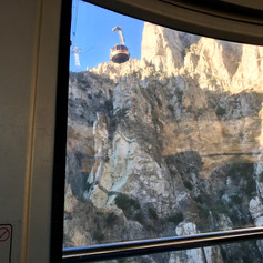
Palm Springs Aerial Tramway: What a neat way to reach a trail-head!! This tramway is really a unique adventure attraction - a unique engineering marvel featuring the world's largest rotating tram cars. It's about a 10-minute, two and a half mile trip that begins at Valley Station, elevation 2,643, and takes you to Mountain Station, elevation 8,516 feet. The car can hold 80 people and the floor rotates within the car about 2 1/2 times during the trip. The result is that you have a 360 degree view of incredible scenery during the trip. When you reach the top you are in Mr. San Jacinto State Park, encompassing 50 miles of hiking trails, primitive campgrounds, a ranger station and an adventure center for winter activities during snow season. Mountain Station includes two restaurants, a cocktail lounge, viewing areas, a natural history museum, movie theaters and gift shops.
Photos below from the left: The tramway boarding area; a selfie of Harry and I as we boarded the tram car; a view up the mountain as be begin our ascent; a view of the other tram car coming down as we are going up.
Click Photo to Enlarge - Use Arrows for Next Photo


Below is an downloaded image of one of the tram cars.

The Hike: As we began the hike from Mountain Station I noticed that the temperature was 48 degrees and it was breezy. Harry and I had watched the weather forecast carefully and had a good selection of clothing in our packs for both cold and rain. As it turned out, the weather was perfect for hiking. It was sunny, the temperature in the 50s, and never windy beyond a rather gentle breeze. The map below, and some of the factual information I show about the hike, was taken from the "Social Hiker" and "Hiking Guy" websites. It's 5.5 miles from the trail-head to Mt. San Jacinto Peak.

From the tram station, you walk down a rather steep concrete switchback walkway to the Long Valley Ranger Station where you get a self-issued permit. This permit is primarily a safety document; i.e. you complete the form and leave one copy at the ranger station when you begin your hike, and leave the second copy there when you return. This way they can make sure that everyone who entered the wilderness area eventually returns.
Photos below from the left: The Long Valley Ranger Station, just a short walk from Mountain Station; a map as you approach the ranger station of all the trails available to hike; a list of things important to have with you on a hike (when you enlarge these photos you can read the map and the list of hiking essentials); and last shows Harry starting up the trail - as you can see, it's a rocky trail.
Click Photo to Enlarge - Use Arrows for Next Photo


Although the trail is very rocky, it's not difficult to follow and periodically (every few miles) there are signs so you can make sure you haven't taken a wrong turn. The trail mainly follows a seasonal creek up the valley until you reach the Round Valley junction at a little over 2 miles. There are campsites in Round Valley for those that want to stay overnight. At the Round Valley sign we had reached 9,100 feet and had hiked a little over 2 miles. The second photo shows that we are 3.3 miles from our objective - the Peak.
Click Photo to Enlarge - Use Arrows for Next Photo


From the Round Valley junction the trail climbs steadily for about 1 mile where you come to Wellman's Junction and have reached the elevation of 9,700 feet. As with all the junctions there are several choices of trails you can take. As this sign post says, it is still 2.3 miles to San Jacinto Peak.
Click Photo to Enlarge - Use Arrows for Next Photo


The two photos below show the full range of the type of the trails you face during the hike. In the first photo you can hardly make out the trail; the trail in the second photo is well marked and maintained (and somewhat level!). Most of the trails are somewhere between the condition shown in these two photos.
Click Photo to Enlarge - Use Arrows for Next Photo


From Wellman's Junction you head north towards San Jacinto Peak. This trail runs diagonally across the east flank of Jean Peak, pausing briefly at a flat cleft at 10,000 feet before continuing north on the east side of San Jacinto. These are photos taken on the diagonal portion of the trail looking down at the valley in the Palm Springs area. The view is gorgeous in person.
Click Photo to Enlarge - Use Arrows for Next Photo


Also along the diagonal portion of the trail we came across a tree that reminded me of a tree behind our family cabin in Big Bear that we call The Lightning Tree. We try to take photos of our cabin guests at the Big Bear tree.
Click Photo to Enlarge - Use Arrows for Next Photo


Eventually the trail switches back, heading southwest to Saddle Junction, where the trail meets up with Marion Mountain Trail that starts outside the small mountain community of Idyllwild. Here the trail turns north again for the final push to the summit. Shorty we came to the Refuge Hut. From the hut the trail turns into more of a scramble. It gets steeper, and less defined, as it proceeds through huge boulders. The last hundred feet are straight up. Finally you are at the summit. Across the valley is San Gorgonio, Southern California's highest peak.
Photos below from the left: The first two photos are at Saddle Junction with the sign showing trails south toward Idyllwild, and showing that it's just 3/10 of a mile to the Peak. The next two photos show Harry and I at the top - elevation 10,834 feet (and you can feel the affect of the elevation in your breathing).
Click Photo to Enlarge - Use Arrows for Next Photo


After spending a few minutes at the summit we scrambled back to the Refuge Hut where we signed the book in the hut and ate a sandwich before heading back down the mountain.
The first three photos below show us at the Refuge Hut. The idea of this hut is to provide shelter for hikers who may get caught by a surprise storm, or other conditions, where they need refuge. In the second row: The first photo is Harry signing the book to prove that he has been there; the next photo shows a cupboard containing emergency supplies, and the last photo shows one of the four beds provided if someone needs to spend the night (the girl doesn't come with the bed).
Click Photo to Enlarge - Use Arrows for Next Photo


We came back down the mountain quicker than we went up, but walking down trails covered with rocks, many quite large, can be tricky and is not conducive to speed. The round trip hike is approximately 11 miles, with an elevation gain of about 3,000 feet measured from the ranger station. The concrete switchback walkway I mentioned at the beginning, goes steeply up to the tramway and is not an easy way to end the hike. Including a brief lunch, we were on the mountain for about 7 1/2 hours.
A Little Background:
Mount San Jacinto State Park is in the San Jacinto Mountains, of the Peninsular Ranges system, in Riverside County, California. A majority of the park is within the Santa Rosa and San Jacinto Mountains National Monument. It is accessible by the Palm Springs Aerial Tramway and lies on the Pacific Crest Trail.
The deeply weathered summit of Mt San Jacinto stands 10,834 feet above sea level, the highest point in the San Jacinto Range and second highest in Southern California. No more than a two hour drive from either Los Angeles or San Diego, the mountain's magnificent granite peaks, subalpine forests, and fern-bordered mountain meadows offer a unique opportunity to explore and enjoy a scenic, high-country wilderness area. The park offers two drive-in campgrounds near the town of Idyllwild. Most of the park is a designated wilderness area enjoyed by hikers and backpackers. Starting in Chino Canyon near Palm Springs, the Palm Springs Aerial Tramway takes passengers from Valley Station to Mountain Station on the edge of the wilderness. In Long Valley, a short walk from the station, is the Long Valley Ranger Station, a picnic area with barbecue stoves and restrooms, a ski center, a self-guiding nature trail, and Desert View Trail which offers panoramas of the high country including several peaks over 10,000 feet in elevation.
The Pacific Crest Trail is the jewel in the crown of America's scenic trails, spanning 2,650 miles from Mexico to Canada through three western states. The trail passes through five California State Parks, Mt San Jacinto being one of them. The others in Southern California are Silverwood Lake and Anza Borrego Desert, and Castle Crags and McArthur-Burney Falls in Northern California.
Comments