
HARLEY RIDE - HOG $100 CHALLENGE RIDE
- Apr 28, 2018
- 10 min read
"Motorcycle riding gives you a sense of freedom you don't get in a car.
Your senses take on a different significance."
"You don't always need a plan. Just go!"
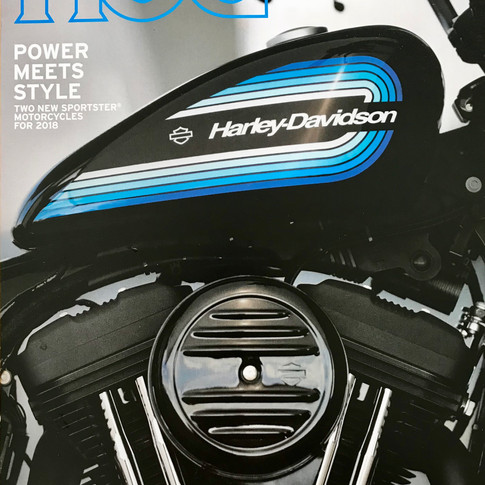
When I created my Updated Bucket List for YEAR 77 I included designing and doing a HOG $100 Challenge Ride, and submitting the story to the Harley Owners Group (HOG) for publication, as one of the key items. I joined the Harley Owners Group when I purchased my first Harley-Davidson motorcycle. Being a member of HOG provides many tools and benefits, including an annual Touring Handbook, local HOG Chapters where you can share the passion for riding, participating in group rides and safety rides, access to Roadside Assistance, and a subscription to the HOG magazine. Each HOG magazine (first photo below is the cover of the 044 issue received in early 2018) includes a $100 Ride story submitted by a HOG member. Magazine requirements are that the story must be interesting enough to be selected, total 750 words or less, the ride must cost less than $100, and include photography from the adventure. The second photo is from a 2013 HOG issue and was the new 2014 Street Glide Special. I bought that exact bike not long after I saw the photo in the magazine.
Click Photo to Enlarge -- Use Arrows for Next Photo


BRIEF SUMMARY OF MY RIDE:
The HOG day-ride I designed began and ended at our cabin in Big Bear Lake. That meant that my total ride involved three days; a ride to Big Bear on Day 1, the HOG ride on Day 2, and a ride back home on Day 3. I left home in Monrovia on a Tuesday morning, rode to Big Bear and stayed overnight at our cabin. I left early Wednesday morning to begin the HOG $100 Challenge Ride. I rode round-trip to Lucerne Valley in the desert, to the Palm Springs Aerial Tramway, did a quick visit to the mountain community of Idyllwild, and rode back to Big Bear through Yucaipa - an eleven-hour ride (including visits) and a round trip of 291 miles. On Thursday I rode back home to Monrovia. If I submit the Wednesday ride to HOG magazine, I will need to modify what is shown in this blog by removing many of the photos and reducing the word count.
Tuesday, April 24th-
I left home in Monrovia about 8:30 am for the ride to Big Bear, using what we call the "front way." The first part of the ride is 50 miles on freeways to the town of Highland located along the mountain foothills. I entered the San Bernardino National Forest on Highway 330 a little after 9:30 am and immediately felt more relaxed and more excited about the ride. The first photo below is as you enter the mountains, the others are from a little higher up.
Click Photo to Enlarge -- Use Arrows for Next Photo


After about 16 miles on Highway 330 you reach the town of Running Springs and you transition to Highway 18. Highway 18 goes through Arrowbear, past the Green Valley turnoff, by Snow Valley Ski Resort, around what is called "Arctic Circle" and arrives in Big Bear at the dam on the west end of the Bear Valley. From Running Springs to our cabin is another 20 miles and I arrived about 10:30 am. The first photo below is taken from the beginning of the Arctic Circle and shows Big Bear Lake in the far distance; the second photo is also taken from the beginning of the Arctic Circle and shows more of the Arctic Circle, which was a difficult construction feat as the highway was carved out of the side of the mountains; the third photo shows San Gorgonio Mountain in the next valley to the south, the highest peak in Southern California at 11,503 feet; and the final photo shows the flowers blooming in front of the Big Bear Civic Center (the flowers were more impressive in person than shown in this photo).
Click Photo to Enlarge -- Use Arrows for Next Photo


Wednesday, April 25th - The Official HOG $100 Challenge Ride
RIDE TO THE TRAM
By Ron Hadfield --- Member US0694467
I've been riding the mountain roads and freeways in Southern California regularly ever since buying my first Harley in 1993. I rode a 1994 Heritage Softail Special for 12 years, then a 2006 Road King Classic for 7 years, and purchased my current ride in October 2013, a 2014 Street Glide Special. See photos of these motorcycles in that sequence below.
Click Photo to Enlarge -- Use Arrows for Next Photo


Riding a motorcycle is always enjoyable, no matter whether it’s just a “spur-of-the- moment” ride, a work related commute, or a planned weekend get-a-way. At age 77, and a rider for over 25 years, I've been on my share of interesting rides. But, I think the most enjoyable rides are those that include a specific destination or attraction. Recently I planned a day-ride that had the Palm Springs Aerial Tramway as the specific attraction and I would like to share this ride with other HOG members. The route includes great scenery, winding mountain roads, significant elevation changes, quaint mountain towns and cafes, Mojave Desert vistas, and a Harley-Davidson Dealership, in addition to the Tramway attraction. A route map is shown below, beginning at Big Bear and going clockwise. Part of what made this ride interesting to me is that there are significant changes in elevation and temperature during the course of the ride. I have highlighted these changes in the text as I tell about the trip.

Below is a shot of one of the tram cars, the primary destination of this planned adventure. The photo of the upcoming tram is taken from the other downward bound tram, with the desert in the background.

Big Bear - elevation 6,752 feet - 40 degrees at 6:30 am
The ride began at our family cabin in Big Bear Lake, California, which is in the San Bernardino Mountain Range about a 3-hour ride east of Los Angeles. Before leaving town I had an early breakfast at the Grizzly Manor, a local favorite in Big Bear.
The owner and cook at the Grizzly when we first began going there was a retired Army Sargent named Don Cook. He had opened the cafe in 1975, just two years before we bought our cabin. He was a great cook and was quite a character, always cracking jokes and making fun of the locals he knew. If you were to ask his full-time waitress, Laura, for a cup of coffee, she would usually say, "Don't you know where it is?" Jayme Nordene, who served in the Navy, purchased the cafe from Don in 1992. Jayme has carried the humor and good food reputation forward. The Grizzly is always packed early in the morning by the locals, and later by the tourists who are willing to wait to get in. Jayme is with me in the second photo below; the 2nd row shows how the place is decorated - the walls are covered with clever sayings, photos, jokes, etc. etc. - about anything you can imagine.
Click Photo to Enlarge -- Use Arrows for Next Photo


Lucerne Valley - elevation 2,953 feet - 66 degrees at 7:45 am
I left the Grizzly and rode Highway 18 north off the mountain, a scenic and curvy road with a drop in elevation of 3,800 feet, to Lucerne Valley in the southern Mojave Desert. The first photo is looking at the desert below from the road going down the mountain, and the next two photos are after arriving in Lucerne Valley, but south of the business and residential community.
Click Photo to Enlarge -- Use Arrows for Next Photo


From Lucerne Valley I rode south on Highway 247, also called Old Woman Springs road, through Johnson Valley and to Yucca Valley where I arrived at about 8:45 when it had climbed to 79 degrees.
Palm Springs - elevation 472 feet - 86 degrees at 9:00 am
I took Highway 62 from Yucca Valley to the Palm Springs Harley Davidson Dealership. The people there were very friendly, as they seem to be at all the Harley Dealerships I have visited. They gave me a bottle of cold water to drink as I walked around looking at bikes and clothing. The first photo below is obviously the dealership; the second is Mt San Jacinto, location of the Palm Springs Aerial Tramway, taken from near the dealership. The third photo shows a 2018 Softail Deluxe, which looks very much like my 1994 Heritage Softail Special. I'm thinking a guy should have two Harleys. The last photo shows that I saved a few bucks by buying a T-shirt instead of another motorcycle.
Click Photo to Enlarge -- Use Arrows for Next Photo


Idyllwild - elevation 5,413 feet - 69 degrees at 10:30 am
I left Palm Springs Harley-Davidson about 9:30 am and went west on I-10 for about 20 freeway miles, then turned south on Highway 243 in the Banning area and rode 25 miles up a very twisty, scenic road to the little town of Idyllwild in the heart of the San Jacinto Mountains. There are tall pines and cedar trees all around, and great views in every direction. The first photo below looks back at the city of Banning as I began climbing a fairly steep section of Highway 243. The second photo is from the same spot, but looking back east where I had come from Palm Springs. The next images are in the Idyllwild area and show some of the great scenery that is prevalent all the way up the mountain.
Click Photo to Enlarge -- Use Arrows for Next Photo


Initially I had thought about having lunch at one of the neat, small cafes in town - I really like the Red Kettle Cafe - but it was still early, so I decided the visit was worth it just for the great ride up the mountain. I turned around and headed back down the mountain and to the Palm Springs Aerial Tramway to have lunch in the Mt. San Jacinto State Park. As I left Idyllwild I noted that I had accumulated 143 miles so far on the trip.
Valley Station - Palm Springs Aerial Tramway - elevation 2,643 feet - 90 degrees at 12:00 pm
I rode back down Highway 243 to Banning (just as fun riding down as going up), went east on I-10, then took Highway 111 to Tramway Road, and rode up to the base area of Mt. San Jacinto State Park where the Valley Station for the Tram is located. I was instructed to park in a specific lot that has a section just for motorcycles and is just a short walk to Valley Station.
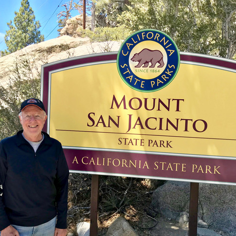
The Palm Springs Aerial Tramway is a unique adventure attraction -- an engineering marvel featuring the world's largest rotating tramcars. It travels over 2½ miles up the cliffs of Chino Canyon, transporting riders up over 5,800 feet in elevation to the pristine wilderness of the Mt. San Jacinto State Park. During the ten-minute journey, the tramcar rotates two full turns slowly, offering spectacular views of the valley floor below and the surrounding cliffs. The first photo below is as we were leaving the Valley Station heading for the top; the second photo shows the other tram on its way down as we are going up; the last two photos are looking down to the desert floor below.
Click Photo to Enlarge -- Use Arrows for Next Photo


Mountain Station - Palm Springs Aerial Tramway - elevation 8,516 feet - 68 degrees at 12:15 pm
When I arrived at Mountain Station I took a few minutes to explore the amenities there.
Tourists can enjoy two restaurants, observation decks, a natural history museum, two documentary theaters, and a gift shop. There are over 50 miles of hiking trails, including a hike to Mt San Jacinto Peak, that has a summit of 11,833 feet. I enjoyed the view from several of the observation decks , purchased an Aerial Tram T-shirt (just what I needed is another T-shirt), and then had a delicious Caesar salad at the Peaks Restaurant. I caught the next tram down to begin my ride back toward Big Bear. The first two photos below are at the mountain-side observation deck, then a view of Peaks Restaurant, and finally a shot from the tram on the way back down.
Click Photo to Enlarge -- Use Arrows for Next Photo


After a great experience riding the Tram and visiting Mountain Station, I left the Valley Station at about 1:30 pm to begin the ride back to Big Bear. The temperature as I left was 92 degrees. I rode Highway 111 back to I-10 west, and went to the Beaumont area where I turned north on Highway 79. I rode through Beaumont, Cherry Valley and Oak Glen to the small city of Yucaipa. The scenery during this ride was wonderful - there were cattle and horse properties, forested hills, and orchards. I included a couple of photos below. Yucaipa is very close to Highway 38 that climbs the San Bernardino Mountains back up to Big Bear.
Click Photo to Enlarge -- Use Arrows for Next Photo


Onyx Summit on Highway 38 - elevation 8,443 feet - 68 degrees at 3:45 pm
From Yucaipa it’s about 50 miles back up to our mountain home and it’s a beautiful ride as you pass Angelus Oaks and go over Onyx Summit, one of the highest roads in Southern California. It passes by the San Gorgonio trailhead, the highest peak in Southern California, having a summit of 11,503 feet. Highway 38 is designated a Scenic Highway by the California Department of Transportation. The first photo below is as you enter the mountains; the second photo is at the Oaks Restaurant in Angelus Oaks where I intended to stop for a libation and found they were closed; then Onyx Summit, only about a 20 minute ride from our cabin.
Click Photo to Enlarge -- Use Arrows for Next Photo


I arrived at our cabin in Big Bear about 4:15 pm with 291 miles on the odometer. Thinking back on the day, it seemed a long time ago when I was talking with Jayme at the Grizzly for breakfast (well, it was 10 hours ago), or with the people at Palm Springs Harley-Davidson Dealership (well, it was over 7 hours ago). Anyway, it was a relatively long day, but a wonderful day-ride with lots of interesting roads and scenery, and a great experience at the Palm Springs Aerial Tramway.
Thursday, April 26th-
I left Big Bear early Thursday morning and had a pleasant and uneventful ride home down the front way, reversing the ride I took up the mountain on Tuesday. I really enjoyed my three days on the Harley. I'll spend some time modifying the information included in this blog for Wednesday, "The Tram Ride" in order to submit it to the Harley HOG magazine. I'll need to eliminate many photos and reduce the word count in order to meet their specifications. Even if my submission to the Harley magazine is not published, I really enjoyed the ride and feel the time spent was worthwhile.
Comments